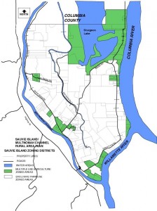
The following information is taken from the Sauvie Island/Multnomah Channel Rural Area Plan:
MULTIPLE USE AGRICULTURE definition: (in map below MUA land is represented in green)
The Multiple Use Agriculture (MUA) zoning district applies to lands for which an “exception” to Goal 3 (Farm Land) of the Oregon Statewide Planning Program has been justified. It applies to agricultural lands not suited to full-time commercial farming because of other factors and is intended to conserve these lands for part-time agricultural practices and other compatible rural development. It is applied to approximately 3,600 acres in the plan area, 2,400 acres of which are on Sauvie Island. This acreage includes the Sauvie Island Wildlife Area (excluding the water area of Sturgeon Lake) as well as lands on Sauvie Island which are divided into smaller lots and mostly developed with existing homes.
These lands have approximately 151 existing dwellings. While the minimum lot size for new subdivisions in this zoning district is 20 acres, most lots in this area are already less than 20 acres in size (and most are less than ten acres in size. No additional subdivisions are possible in Multiple Use Agriculture-zoned areas. While lots along the west side of Multnomah Channel are theoretically subdividable into 20 acre homesites, the existence of wetlands and floodplain areas on these lands would make such subdivisions very difficult to meet all necessary development standards. All of the potential additional dwellings lie on existing legal parcels of less than 20 acres in size.
MUA Zoned Area Acreage Existing Dwellings
Sauvie Island Wildlife Area: 1,700 acres; 28 dwellings
Gillihan Road (north): 75 acres; 12 dwellings
Gillihan Road (middle): 65 acres; 7 dwellings
Gillihan Road (south): 270 acres; 28 dwellings
Lucy Reeder Road: 75 acres; 12 dwellings
Sauvie Island Road-Reeder Road: Charlton Road: 220 acres; 57*dwellings
West Side of Multnomah Channel: 1,200 acres ; 7*dwellings
Totals: 3,605 acres 151* dwellings
*Not including floating residences

