It is approximately a 50-mile trip to circumnavigate Sauvie Island!
Boating rules and safety
- No Wake zones are posted on both sides of the Multnomah Channel north and south of the Sauvie Island bridge; south of Sauvie Island moorage and the north end of Mayfair Moorage (at Pier Road boat launch). Please show consideration to our floating homes residents. See Oregon State Marine Board website for more information on wakes.
- Multnomah Channel is popular in summer. Boaters be careful for water skiers and tubers in the water.
- After heavy rains there is a large amount of floating timber in both the Multnomah channel and Columbia River. These are often times largely submersed. Slow is the recommended speed.
Boat Ramps and docks
- Sauvie Island Boat Ramp – located at the end of Ferry Rd across from Fire Station on Sauvie Island Road. Has an adjoining parking facility and bathrooms maintained by Portland Metro.
- Hadley’s Landing – borders Wapato State Greenway on the Multnomah Channel is a boat dock and small picnic area with a seasonal port-a-potty, picnic tables and horse-shoe pits.
- Cove Marina – lies in a small inlet on the Sauvie Island shore just upstream from Willow Point. A Launching ramp is available but no fuel.
Kayaking
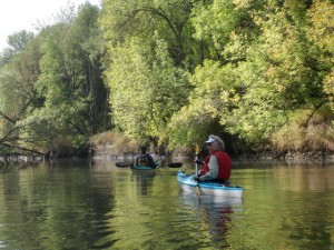
The Multnomah Channel or the Columbia River waters which border the island are obvious paddling waterways; however both have a lot of boat traffic which may include barges, sailboats and power boats and additionally, the Columbia River sees heavy ocean-going container-ship traffic. The Cunningham Slough provides easy water kayaking.
A great family paddling option is Sturgeon Lake where there is a boat launch.
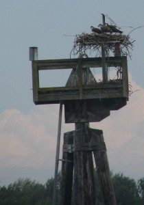
Please take care not to disturb waterfowl and other bird or wildlife nesting areas that may be found along beaches and atop piers and pilings such as the Osprey nest pictured right.


